The work stuff. It’s all here! Arranged by ‘date started’ – so concurrent roles might seem out of order, but there is method in the madness. Some more focused career journeys are also provided:
Polar fieldwork, guiding, related roles
Community building and volunteering
Current
Freelance geospatial consultant, Spatialised (https://spatialised.net)
Key attributes: innovation, project management, leadership, collaboration, business development, technical expertise, customer service
Occasional contracts 2015-2018, full time 2018 to late 2020, restarting in 2023.
Clients include:
- HyVista Corporation (2024/25): airborne sensor operation.
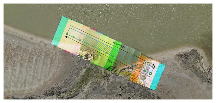
- Taungurung Land and Waters Council (2024): drone image capture.
- Mammoth Geospatial (2023): specialist lidar processing and product QAQC.
- North Road Geospatial (2023): drone mapping SME advisory consulting.
- Australian National University (2020): report proposing an open source system architecture for the Australian Scaleable Drone Cloud, including technical proofs.
- Australian Capital Territory Emergency Services Agency (2019): scaleable cloud based image processing in partnership with 2Pi Software.
- Australian National University Fenner School (2018): introductory lidar teaching materials, refactoring forest metrics code into Python.
- FrontierSI (2019): geospatial SME consulting and method prototyping on QA4MBES and QA4UAV products
- the Australian Antarctic Division (2013, 2015): shipping analysis including cartography showing shipping route frequency and developing symbology for shipping incidents; sea ice lidar project wrapup.
As the owner and principal consultant I work on client engagement and business development, project management using agile practice, resource and budget management. I also provide subject matter expertise and developed geospatial components of projects using Python, open source geospatial and image analysis tools (PDAL, GDAL, OpenCV, QGIS) – with occasional Javascript hacking (for example TerriaJS) to deliver concept proofs.
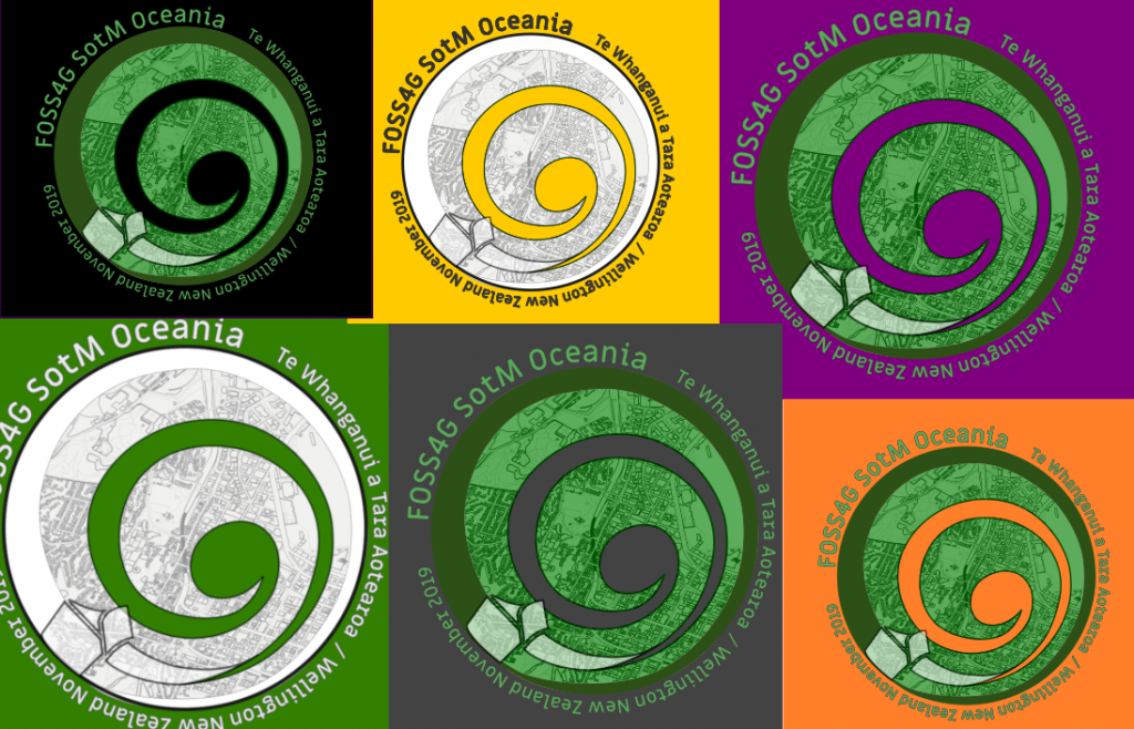
Spatialised was a sponsor of the 2019 FOSS4G SotM Oceania conference. The business was forced to slow down by an intense wildfire season in 2019/2020, then COVID – and was parked while I worked in Norway. In 2023/24 the books have opened again, ready to help with your geo- and geo-aligned needs.
Related portfolio work


March – June 2024
North Central District Operations Coordinator, Parks Victoria (https://parks.vic.gov.au)
Key attributes: leadership, budget development, budget management, team development, risk assessment, business strategy
Fixed term role delivering coordination of resources across Victoria’s North Central region, reporting to the District Manager. Work with Area Chief Rangers, Ranger Team Leads and the District Manager to identify priority tasks and plan annual budgets to support delivery of the Parks Victoria regional strategy. Work with ranger team leads to ensure that work centres are compliant with Parks Victoria essential safety measures and business operational principles. Gather and advocate for personal development and infrastructure needs across the district, in collaboration with the district leadership and district management teams. This role also has a fire component, deploying as a general firefighter to assist in planned burn management with Forest Fire Management Victoria.
July 2023 -January 2024
Field Operations Manager, Biik Cultural Heritage Unit, Taungurung Land and Waters Council (https://taungurung.com.au)
Key attributes: leadership, change management, communication, accountability
A newly created role aimed at providing sustainable operational structure to cultural heritage fieldwork activities across Taungurung country. Leading and mentoring a team of 14 line reports, undertaking risk assessments, developing and executing operational plans, rostering, communicating and working toward structural change. Requires an understanding of the intersection between WHS regulation, indigenous cultural heritage legislation and culture as valued and practiced by the Taungurung nation today.
2021-2023
Director, the Open Source Geospatial Foundation (OSGeo): https://osgeo.org
Key attributes: leadership, mentoring, community maintenance, capacity building, advocacy
Working with a spatially and culturally diverse team of directors to support a passionate community of open source geospatial software developers. Duties involve planning and setting budgets, forming and maintaining partnerships, resolving conflicts, and representing the open geospatial community in local and international forums. Elected for a two-year term in December 2021. Key achievements were the resolution of an MoU with the European space agency, supporting FOSS4G conferences in Firenze and Kosovo,
2020-2023
Postdoctoral researcher, Norwegian Polar Institute.
Key attributes: mentoring, research, polar fieldwork, safety, risk management, collaboration, advocacy
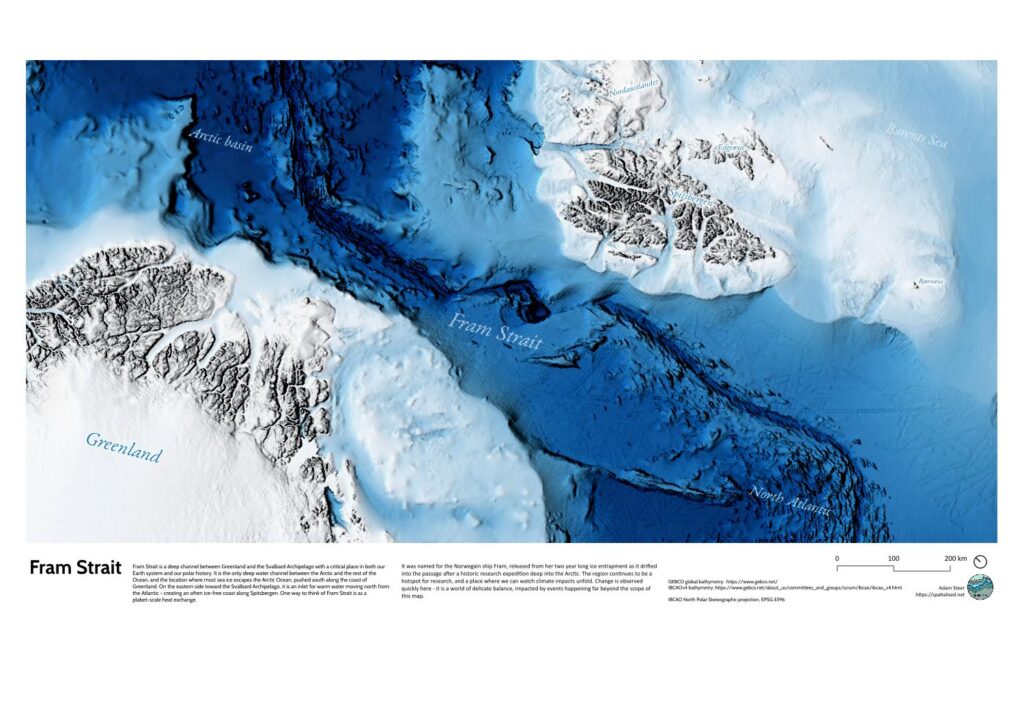
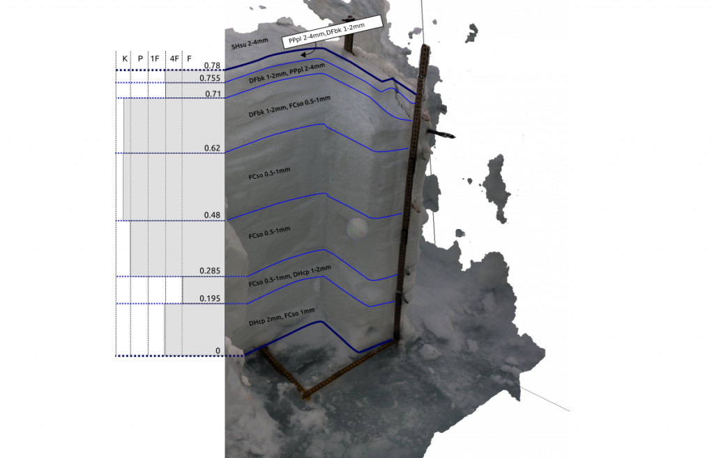
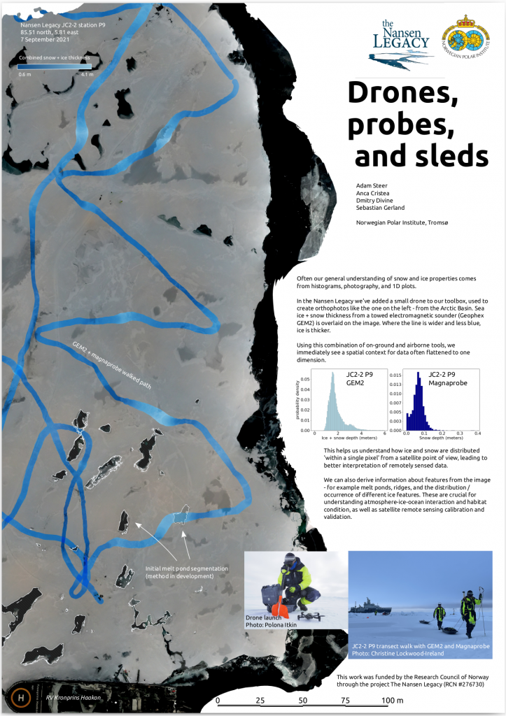
I was a sea ice physical properties specialist in the Norwegian Nansen Legacy Project (https://arvenetternansen.com). My work mixes traditional sea ice sampling using drills, ice corers, ship based observation and detailed snow pits – and new strategies using small drones, semiautomated snow probes and electromagnetic sounders. Overall, the aim is to help unpack how sea ice physical structures interact with the living environment of the norther Barents sea.
I worked in a huge variety of sea ice conditions working off RV Kronprins Haakon in winter (March 2021, February / March 2022), spring (May 2021) and at the start of the Arctic refreeze (September 2021), travelling up to 87.5 degrees north.
The role had strong risk management, field leadership, and safety components. I developed and helped shape risk assessments. I was responsible for continuous assessment of operational sea ice safety, finding safe routes and leading small groups in unexplored sea ice terrain. And I worked as a dedicated polar bear guard.
This work contributed to a best possible picture of sea ice structure to a broad, multi-disciplinary project. It also contributed to innovative usage of small RPAS (drones) in sea ice research. Finally, it had a strong advocacy component – speaking up internally and externally about how temporary researchers are percieved and treated in the Norwegian system, trying to improve conditions for people who come after me.
Related portfolio work
2018-2019
Sponsorship lead, founding director, elected director, OSGeo Oceania (https://osgeo-oceania.org)
Key attributes: community building, community maintenance, fundraising, mentoring, collaboration, leadership
In 2018 a community got together and ran the first open source geospatial software conference in the Oceania region since FOSS4G 2009. I led the effort to raise money for the event, and created the Good Mojo program which allocated funding specifically for DEI initiatives – for example travel grant programs, funding the inclusion of children at conferences, and networking events.
Based on the incredible success of that event, the organising committee formed a not-for-profit company, OSGeo Oceania, to support future events and the community in general. I was a founding director, then elected director.
2017-2018
Geospatial research lead, Synthesis TechnologiesKey attributes: technical awareness, business development, rapid prototyping
Key attributes: technical awareness, cutting edge skills, agile projects, business development, product development, rapid prototyping, teamwork
I was the first employee of Synthesis Technologies, a small startup with a huge vision – we did metaverse before it was cool, taking an open source stack and pioneering exploitation of massive point clouds in XR / mixed reality, initially working on a product for situational awareness training with a defense focus.
We funded a lot of work on the open source point cloud viewer Potreetechnical awareness, business development, rapid prototyping (https://potree.org), sponsored the first FOSS4G SotM Oceania conference, and built tools nobody thought would be possible – dynamic viewsheds using point cloud data, and near-seamless exploration of multiple datasets from centimeter to multiple-suburb scales.
Synthesis Technologies and I ended our relationship amicably after hitting some deep impasses in our philosophical outlooks, and my leap intnical awareness, business development, rapid prototypingo independent consultancy was powered by a seed project from Synthesis Technologies.
2016 – 2017
Senior earth systems data specialist, Australia’s National Computational Infrastructure.
Key attributes: research customer interaction, training, service development, teamwork, concept leadership, research
I was hired into a role mixed between researcher advice and training, and implementation / development of new data services. In this role I delivered workshops on using NCI services, provided advice to researchers on data storage and management, solved problems with existing data services and tried to address gaps by exploring new ways to deliver NCI’s geospatial data holdings.
I played a key role in delivering the NCI component of Earthserver2, a European Union Horizon2020 project working with collaborators in Italy. I brought an OGC standards based point cloud delivery service to working prototype, presented at the European Geospatial Union and FOSS4G conferences in 2017.
I developed and delivered training on both NCI services and OGC data service standards.
2014 – 2016
Workshop / sales, Uni Cycles, Canberra, Australia.
Key attributes: customer service, precision, technical skill, deep product knowledge, mentoring
Mechanic and salesperson at a small bicycle store in Canberra, Australia. My role included bicycle salea and servicing, daily triage of bicycle servicing tasks, service and sales bookings, keeping tabs on stock levels, and mentoring new staff.
2009-2016
Doctoral candidate, Surveying and Spatial Sciences, School of Land and Food, University of Tasmania.
Key attributes: project leadership, concept development, polar logistics, fieldwork, field team management, mentoring, helicopter operations, safety assessment, risk assessment, data analysis and synthesis, project prioritization
I won an Australian Postgraduate Award to fund my doctoral candidature in 2009, based on a proposal using airborne lidar to estimate Antarctic sea ice thickness.
This journey started in geodesy, understanding concepts about very long baseline GNSS positioning in order to accurately locate a helicopter borne laser scanner deep in the drifting pack ice around Antarctica. It then took a deep dive into modelling sea ice thickness from altimetry, understanding the impact of snow distribution, and getting to know sea ice as a highly complex composite material.
It then led to a novel ground survey method, setting up a coordinate system which drifted and rotated with the ice and tying airborne, ground and under ice observations together in space and time. A significant step was adapting a lidar georeferencing method which provided uncertainty bounds for every single point. This allowed rigorous propagation of uncertainties through to modelled snow and ice properties.
My doctoral thesis (see publications) provides engineering and data analysis details. Its main finding is that our body of knowledge about Antarctic sea ice thickness is extremely limited because of observational and resolution-induced biases. It also highlights some critical issues in estimation of snow depth on Antarctic sea ice.
I was funded full time from 2009 to mid-2013, after which I self-funded the project to completion. It took a total of 4.5 years full time equivalent.

2007-2013
Sea ice technician (also known as research engineer in other countries), Australian Antarctic Division, Hobart, Tasmania
Key attributes: project leadership, concept development, polar logistics, fieldwork, field team management, mentoring, helicopter operations, safety assessment, risk assessment, data analysis and synthesis, project prioritization
I coordinated logistics and field support for the sea ice physical processes team in the Australian Antarctic division on four expeditions to the east Antarctic pack ice zone. Two were international multi-disciplinary research expeditions ( SIPEX 2007; SIPEX II, 2012) and two were resupply trips to Davis Station (V1 2008; V1 2009). In 2009 I was also a voyage management intern – meaning I worked with the expedition leadership team in addition to my research role, to understand the process of running a resupply expedition.
On these expeditions my focus was an airborne surveying platform and supporting ground observations. In 2007, 2008 and 2009 I flew a lot as an airborne camera operator, in 2012 this role was largely ‘set and forget’. In 2007 and 2012 I managed a ground surveying operation using GPS and other surveying equipment, drills, sleds, shovels, sweat and a small cohort of volunteers recruited on the ship in addition to our formal research team. On all voyages I worked as a sea ice observer, contrbuting to the ASPeCt program.
My “off ship” work aimed to tie data collected in all these programs together – integrating airborne lidar, photogrammetry, ship based observations and in situ sampling. It pioneered the use of texture based image analysis and the application of structure-from-motion photogrammetry on drifting sea ice.
2005-2008
Hiking guide, Cradle Mountain Huts (now Tasmanian Walking Company)
Key attributes: leadership, mentoring, customer service, sensitive landscape operations, landscape interpretation
Between 2005 and 2008, I walked 27 groups along Tasmania’s Overland Track. I was promoted to senior guide early in 2005. Responsible for guest briefings, care, group management, first aid. Also interpretive guiding , cooking, cleaning and minor hut maintenance in a world heritage wilderness area. This role also included mentoring and training new guides, and coordinating with other guided parties as needed for emergencies or general camaraderie in the park.
As a commercial operator in a world heritage wilderness area, we were also responsible for taking care to minimise the impact of our work on the area, working within management plans and legislation applicable to the wilderness world heritage area, and working to ensure we were doing better than providing a ‘tick-a-box’ experience.
Pre-2005
Student – Bachelor of Antarctic Studies (honours), Institute of Antarctic and Southern Ocean Studies, University of Tasmania, 2004.
Web publishing officer, Australian Library and Information Association. 1999-2001 and 2002-2004
Outdoor equipment retail sales, Nevisport, Edinburgh, Scotland, late 2002
Night watch, Caribisdale Castle, northern Scotland, early 2002
Front desk, Banff International Hostel and relief manager, Castle Mountain YHA, Banff and region, Alberta, Canada. May to October 2001
Ski lift operator, Fernie Alpine Resort, Fernie, British Columbia, Canada – winter 2000/2001
Teaching assistant (6 month contract), Canberra Institute of Technology, Canberra, Australia, 1999.